The one stop consultancy services for:
- Arboriculture - Tree Safety Surveys
- BS5837:2012 Tree Surveys
- Forestry
- Countryside Management
- Landscape Architecture
- Ecology
- Noxious Weed Management
- Contract Management
- GIS Training / Analysis/ Map Production / Data Management
- Web Mapping WebGIS
- Mobile GIS Data Capture
- Mobile app for Tree Surveys
- UAV Aerial Imagery & Surveys
- UAV Aerial Imagery & Surveys
BS5837 : 2012 Tree Surveys for development and Planning
Trees in relation to design, demolition and construction. Recommendations (April 2012).
We have provided BS5837 tree survey reports to several Government Agencies, Councils, Schools, Universities, Housing Associations, Parish Councils and Utility Companies.
"Where there are trees on a potential development site, as part of planning process the Local Authority (LA) will require a comprehensive tree survey to assess them. This is often known as a pre-development tree survey or a BS5837 Tree Survey."
When used in a timely manner BS5837 development tree surveys will provide guidance to the designers. Using the information within the Tree Schedule and Tree Constraints Plan (TCP) any tree related issues will be put into context in the Arboricultural Implications Assessment (AIA) for the various design options. The finalized design will require a Tree Protection Plan (TPP) and an Arboricultural Method Statement (AMS) that could include details of pre-development tree work, timing and phasing of operations, compliance with Construction Exclusion Zones (CEZs), installation of services, any work required in CEZs and landscaping mitigation and Arboriculture supervision.
Ideally the tree survey should be carried out very early on to inform the design (it should be thought of as the vital 1st step in the design process).
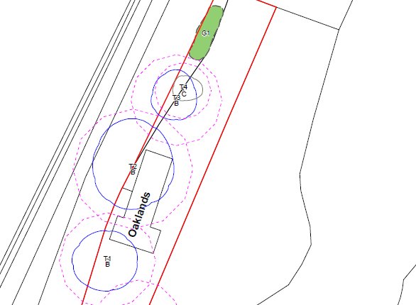
We have worked on large and small tree surveys for development projects that conform to the British Standard BS5837 :2012. These tree surveys help you to understand your tree resource and help the design team to use the appropriate trees within a development project. Where possible we look to retain trees to add significantly to any development but this depends on the appropriate assessment. We use AutoCAD and can produce CAD plans to your requirements that detail the tree No., tree species, tree height and the root protection areas etc.
We can provide:
-
Pre application advice on trees;
-
Tree Survey Reports to satisfy BS5837:2012;
-
AutoCAD drawings for root protection areas;
-
Tree shade analysis;
-
Arboricultural Impact Statements;
-
Method Statements & signage for development sites;
-
Provide advice on protected trees that have Tree Preservations Orders (TPO's) or are within Conservation Areas;
-
Submit Tree Work Applications for protected trees;
-
Provide Arboricultural Clerk of Works;
-
Arboricultural Contract Management & Supervision.
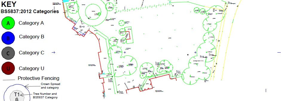
BS 5837 :2012 standard requires that the quality and value of each tree or group or woodland is assessed as one of the following:
-
Category A - High quality and value trees;
-
Category B - Moderate quality and value trees;
-
Category C - Low quality and value trees;
-
Category U - Trees to remove or where any existing value lost within 10 years.
When used effectively the BS5837 survey will
result in the retention of the most suitable trees and create the conditions
necessary to ensure their long-term survival within or around a project,
thereby enhancing the scheme and the local landscape for the future.
We have full access to AutoCAD and a wide variety of GIS software so that we can automate drawing production which saves us time and ultimately saves you money. Topographic Surveys are often needed for planning applications and to help with the design and these are usually provided in DWG/DXF format and preferably to Ordnance Survey Grid. We can convert topographical survey plans into GIS to aid in the field surveys.
Tree Plan Production
We can produce plans for you and it is helpful to receive the tree survey data as an Excel Spreadsheet to save time and costs and the template below can be used.
From the tree survey schedule we can produce:
-
Tree Constraints Plan (Abbreviated to TCP) showing root protection areas (RPA's);
-
Tree Protection Plan (Abbreviated to TPP);
- We also produce Arboricultural Implication Assessments (AIA).
The 'Root Protection Area' (RPA) of each tree can be accurately plotted on a plan and this illustrates the below ground constraints and should be used at the early planning stage to inform the design especially of ducts and services. The RPA is there to help avoid unnecessary damage to tree roots or rooting environment of retained trees during developments. The RPA is usually plotted around category A, B and C trees.
Other Tree Plans
We are increasingly being asked to produce Tree constraints plans over laid on top of proposed site drawings which enables you to easily identify which existing trees will be impacted upon. This also greatly aids the production of the Arboricultural Implication Assessment which Local Planning Authorities may also request.
For a BS5837 Quote / Estimate please provide the following (if you have it available):
- A map showing clearly the area to be surveyed, a red line around the boundary is often helpful (or an area drawn on Google Earth as a KMLfile);
- Approximate number of trees;
- Provide timescales for Planning Application submission;
- Provide details of any topographic survey (if you have one send it through as DWG/DXF);
- Any areas that need special attention around the edges of the site;
- Any site access restrictions/ constraints or site hazards.

TOPOGRAPHIC SURVEYS - From the outset of the project we can provide detailed topographical surveys for any given site that are captured to the correct specification for all the project team to use. All topographical surveys are not the same.
We use experienced land surveyors to ensure that the survey plans are delivered to the very highest standard, on time and on budget. As they use the latest in survey technology, they are able to collect, process and present the topographic survey information efficiently and accurately in the format you require. This helps with tree surveys and cuts down on time. Contact us to find out more about topographical surveys. For any quote we need a map that clearly shows an outline of where the site boundaries are.
We can also provide Tree Safety Surveys for your land holding and any practical tree planting advice.
Consultancy: GIS - Forestry - Arboriculture - Website Design


