


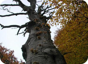
Tree Safety Surveys
We carry out a wide range of surveys from individual trees to County wide surveys.
Presenting Tree Survey Information
We can provide the results of a tree survey in any format that you require from GIS layers, PDF's as well as interactive web mapping sites.
Tree Surgery Work
We work with highly skilled Arborists who can tackle a single tree or carry out Tree Surgery work to several hundred trees.
Countryside Management & Ecology
We offer ecological surveys and undertake the field work alongside other specialism to save time and to share site knowledge.
Low Cost Aerial Imagery
We offer high quality aerial imagery using the very latest Unmanned Aerial Vehicles which can be used effectively for monitoring.
Arboriculture Consultancy
We offer all aspects of arboriculture and provide BS5837:2012 surveys to aid the design process as well as tree safety surveys.


The one stop consultancy services for:
- Arboriculture - Tree Safety Surveys
- BS5837:2012 Tree Surveys
- Forestry
- Countryside Management
- Landscape Architecture
- Ecology
- Noxious Weed Management
- Contract Management
- GIS Training / Analysis/ Map Production / Data Management
- Web Mapping WebGIS
- Mobile GIS Data Capture
- Mobile app for Tree Surveys
- UAV Aerial Imagery & Surveys
- School Catchment Mapping & Ranking

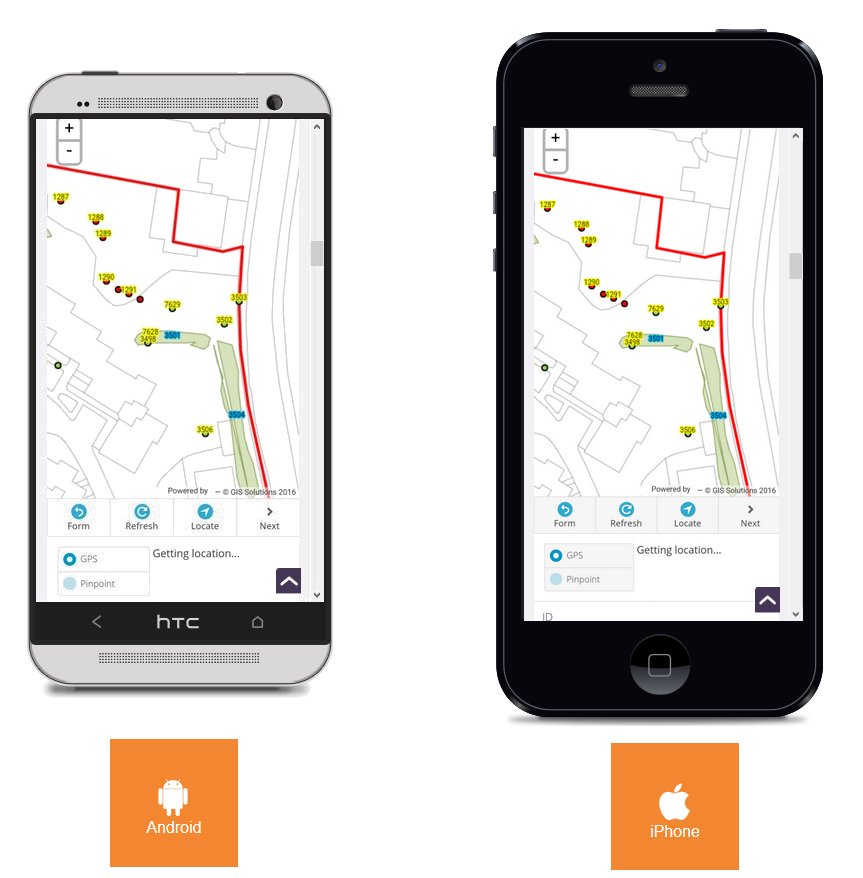
Mobile app for Tree Surveys
Our app was launched in 2017 and we have always ensured that it is simple and easy to use whilst remaining cost effective. We can provide a tree surveying app that can greatly assist in efficient tree data capture especially where there are multiple surveyors. Never lose any data or have to download or e-mail tree data about as our easy to use system simplifies the management of the tree survey data.
This application is being used by Arboricultural Consultants, Housing Associations, Local Authorities and Charities to help manage their trees. It is driven by a map interface and uses the devices built in GPS making surveying trees simple and the positions are accuratly captured.
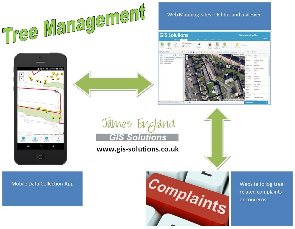
What we can offer?
- A mobile app that can be used to capture, photograph, edit, delete individual trees using a simple and efficient interface so that there is a consistent survey method (for Android and Apple iOS (iPhones and iPads) Smartphones or tablets) ideally with a GPS. Background mapping can be added and this can be available offline.
- A web mapping site for Tree Management. The mobile app sends the tree data into as soon as it is collected (providing the device has a mobile data signal, if not it will queue the data until it has one). Used to view, edit, update, delete, export, report and analyse the tree data.
Tree Survey Mobile app
Our mobile app is available on a subscription basis and we provide the app setup for your use tailored to your particular needs along with the background mapping of your choice, for the duration of your project. We provide first class technical support to get everyone up and running as quickly as possible.
"Available
on a subscription basis for Android and Apple iOS devices"
-
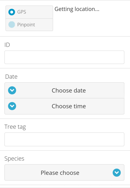
Survey setup - The data capture forms are fully customisable to your requirements and they are easy to use as well as being quick to operate, with minimal training requirements needed. The form can encompass text boxes; drop down boxes, select lists, yes / no questions, date time, location, surveyor, site name, photographs, audio recording etc. Drop down boxes can drastically speed up the survey as well as eliminating spelling mistakes which can greatly assist in providing quality tree data. Coupled with a free text box when you want to record information. The existing tree data can be loaded into the system and setup to be used in the live database.
-
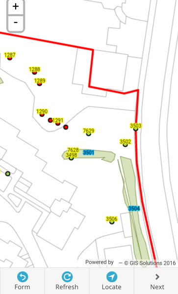
Accurate Location Plotting - Using the devices in built GPS and accurate base maps such as the Ordnance Surveys MasterMap, the map within the app shows in real time where you are.
-
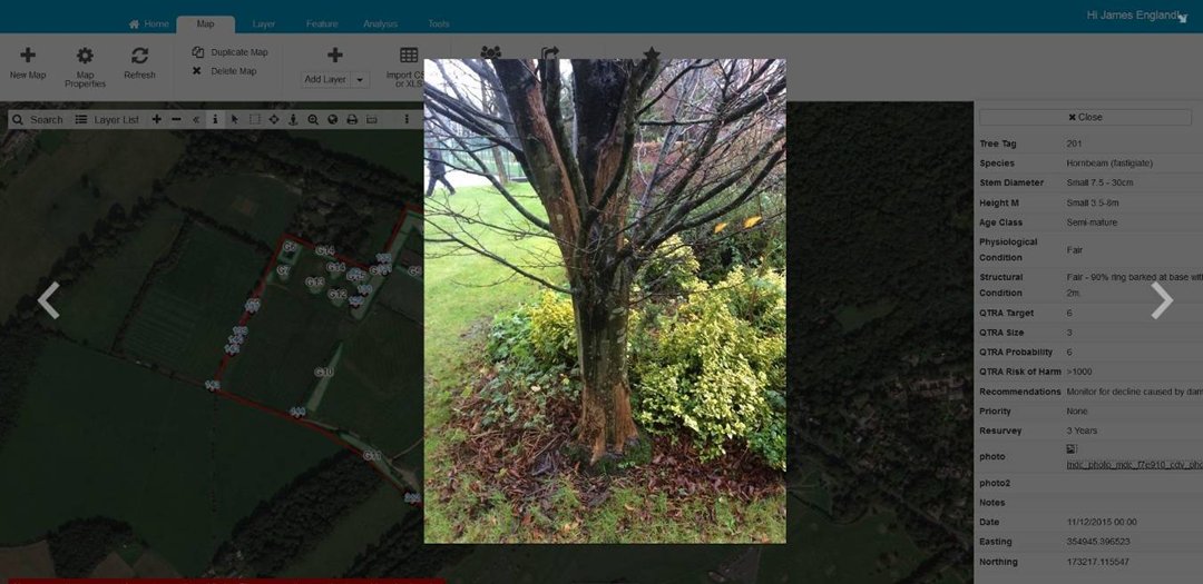
Photographs - View and take photographs of tree defects or to show maintenance work that is needed.
-
Record Audio - Audio can be recorded if your device allows it (most do) and added to the individual tree record. This is very useful for taking notes where the observations and work required are complex.
-
Form Customisation and Streamlining - Using our extensive GIS and tree surveying knowledge we are able to minimise what is captured on site to the important information so that the surveyor spends longer surveying than recording. Information such as address, date and time can be added in the background without the surveyor even having to do anything.
-
Sends Data In Real Time - Once the tree data is captured the survey data is sent in real time using a mobile data signal. It is sent directly into the live database. If a mobile signal is not present the maps can be preloaded so that they can work offline and the tree data captured can be queued on the device until internet access is available at which point it will automatically upload the tree data to the central spatial database.
.jpg)
-
Multiple Surveyors - Where several surveyors are used to tackle larger surveys, the system allows each surveyor to see all the other trees recorded providing you have a mobile data connection. Seeing all the data that has been collected by others eliminates overlap of tree records and saves time.
-
Re-surveying Trees - The system is ideal for resurveys and can incorporate any existing data that you have as long as it is georeferenced or you have a spreadsheet with eastings and northings. We have developed it to show all the previous data as red symbolised trees and as they are surveyed the symbols turn green to show clearly where the remaining trees that need surveying are located. This tree data can be shared in real time to clients so that they can organise important tree work as the survey is being undertaken and there is no need to wait for the survey to be completed. Trees requiring urgent work can be exported from the system as a report, Microsoft Excel, Google Earth kml, shape file, MapInfo, AutoCAD DXF etc this can then be passed onto the Arboriculturalist so they can locate and carry out the required tree work. Alternatively they can be provided with the mobile app to update the tree survey information after carrying out any remedial work.
-
Subscription Licences - Our setup will provide individual app licence for the data collection and the cost depends on the number needed, the duration of the project, the time to setup the form and the processing / purchase of any background mapping data.
-
Background Mapping Data - Our tree surveying app has a versatile map screen along with an uncluttered form page. Within the map any relevant GIS data layers can be added such as Ordnance Survey MasterMap (needs to be properly bought and correctly licensed which we can do), land ownership layers, risk zones, and aerial imagery.
-
-
Data Backups - The system automatically keeps a backup of the data in the event of any accidental removals of tree data.
-
Tree Queries - Any tree queries that are raised can be added to the system for surveying and can appear as a large red symbol alerting the surveyors to a customer complaint.
-
Photographs - can be taken as part of individual tree records and once the data is uploaded from the device running the app it will appear on the web mapping site. This avoids having to transfer photographs manually.
-
Data Backups - The system automatically keeps a backup of the data in the event of any accidental removals of tree data.
-
Review Data - Review your daata directly throught the app from any place in real time.
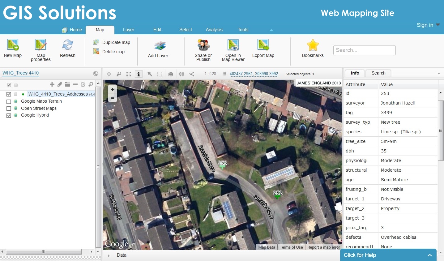
Web Mapping Site (WebGIS) links direct to and from the mobile app for Tree Management
We offer a web mapping site that utilises the latest WebGIS technology to deliver large amounts of geographic data in a fast and easy to use format. Web maps can be used to manage the tree data alongside any other data that you may have. They can show georeferenced data on a map instantly and can often answer questions to enable clients to make quick decisions about their assets, such as which trees need removing due to their location and significant defects. The tree data can be filtered to show all the trees that need felling or all the trees requiring surveyed as part of the tree survey programme. This can be viewed on a map or the selected data can be exported to a variety of formats.
"Our
WebGIS system is very easy to use and allows
access to a wealth of detailed information."
![]()
-
Display Data In Real Time - Using our web mapping site through any internet browser all the data collected can be displayed on the map in real time.
-
Full of Features - The user can pan zoom, search and display the map layers they need and view any linked data such as photographs.
-
Address and Postcode Search - The web mapping site incorporates Google's address search and Google's Streetview which provide further useful information.
-
Export Data Easily - The vector data within the system can be exported to a number of different formats such as Shape file, MapINFO MIF file, Google Earth KML, CSV for Excel and DXF for AutoCAD.
-
Share Data - The data can be shared with other people such as Arborists who will be carrying out the recommended work.
-
Search and Query Your Collected Tree Data - Within the mapping interface it allows spatial queries and analysis to be performed.
-
Create Reports - The system has an inbuilt report function and you can simply select which fields you want in the report. These can be saved to your computer.
-
No Software to Install and always available - Our web mapping system is accessed through the internet without the need to install the application on a local PC. The system can be accessed anywhere giving user flexability.
"We believe that our mobile app provides a streamlined data capture application that saves time and the addition of photographs and seamless data transfer enables all stakeholders to access the tree survey information straight away"
We have recently helped a Local Authority by providing the setup and support for a tree survey and using our system they have been able to compile a streamlined tender where the recording and reporting has already been taken care of.
"It allows real time collaboration and easy exporting of data"
-
On larger tree surveys it is important to have an accurate ownership layer in GIS drawn to the latest Ordnance Survey MasterMap. This will help identify trees that need surveying in the field and also helps as part of any risk zoning exercise for planning future tree management.
Lastly, if you made it this far you have done well....we use this system ourselves to manage trees as part of our Arboricultural Consultancy Service. To find out more please get in touch.

Consultancy: GIS - Forestry - Arboriculture - Website Design